
Machu Picchu is one of those destinations where the approach matters as much as the arrival. The site sits within a specific set of geographical conditions, high Andean terrain, compressed vegetation zones, and a river gorge system that shapes every access route. Travellers who understand these conditions before they leave make significantly better decisions about how to get there, how long to spend acclimatising, and what to expect on the ground.
The Physical Setting: What the Terrain Actually Looks Like
Machu Picchu occupies a narrow ridge at 2,430 metres above sea level, positioned between two peaks, Huayna Picchu to the north and Machu Picchu Mountain to the south, above the Urubamba River gorge. The site sits at the ecological boundary between the high-altitude puna and the upper Amazon cloud forest, which produces a subtropical microclimate that is warmer and more humid than Cusco and the Sacred Valley. The terrain surrounding the citadel is steep and densely vegetated, with weather that can shift within an hour. Fog, rain, and clear skies can occur on the same morning.
Elevation and the Logic of Acclimatisation
Most travellers arrive via Cusco, which sits at over 3,400 metres, a higher elevation than Machu Picchu itself. This is a detail that consistently surprises people. The Sacred Valley, at roughly 2,800 metres, provides a useful intermediate stage, and spending one or two nights there before ascending to Cusco is a recognised way to reduce the impact of altitude change. Geography-first travel resources such as Machu Travel Peru, which focus on terrain-led planning and route-based movement, are particularly useful for understanding why elevation sequencing matters before committing to an itinerary.
Aguas Calientes, the access town at the base of the citadel, sits at around 2,040 metres. By the time travellers reach it after a few days in the highlands, the body has usually had time to begin adapting. Altitude sickness remains a genuine concern for those arriving directly from low-elevation locations, so building acclimatisation time into the schedule is not optional. It directly affects how functional you are at the site and on the trails.
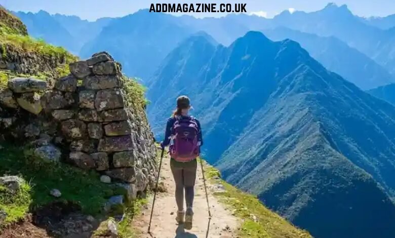
How the Routes Are Shaped by the Terrain
Reaching the citadel is terrain-defined. There is no road directly to Machu Picchu, and all access narrows into corridors dictated by the Andean topography.
The train journey passes through changing vegetation zones, from high-altitude scrub into progressively denser cloud forest, and the canyon walls rise steeply on both sides for much of the route.
Those travelling on foot have several options, each shaped by the mountain terrain they cross. The classic Inca Trail about 43 km over four days, ascending the 4,215-metre Dead Woman’s Pass and then descending toward Machu Picchu. The path follows an original Inca route network, engineered in stone to connect the highland empire across difficult geography. The Salkantay Trek takes a more remote line over five days, passing beneath the 6,271-metre Salkantay peak through an extreme range of altitude and vegetation zones. The Choquequirao Trek adds a multi-day circuit through isolated terrain, connecting two significant Inca archaeological sites separated by deep ravines.
Route selection should be based on physical preparation, available time, and a realistic understanding of what each trail demands. Many of the better Machu Picchu packages combine train access with one of these trekking routes, allowing travellers to approach on foot and return by rail without retracing the same terrain.
The Circuit Structure at the Site
Movement inside the citadel is managed through fixed, one-directional circuits. These are not arbitrary divisions; they follow the ridge topography and the layout of the archaeological zones. Circuit 2 covers the widest ground, passing through both the upper and lower sectors including the Sacred Plaza, the Intihuatana, and the Condor Temple. Circuits 3 and 4 are shorter and lower in elevation, suited to those combining the citadel visit with one of the adjacent mountain climbs.
Huayna Picchu requires a separate ticket and involves a steep, narrow ascent with significant exposure. Machu Picchu Mountain offers a longer, more gradual climb with broad southern views. Both require advance ticket purchase, as access is limited daily and slots fill months ahead during peak season.
The Logistics That Geography Forces
Several practical constraints stem directly from the terrain and site conditions. There are no bathroom facilities inside the citadel; they are located at the entrance only, and re-entry is not permitted once you exit. Disposable plastic bottles are banned throughout the archaeological park. Large bags are restricted. Timed entry tickets operate with strict daily capacity limits, a response to conservation research on erosion and deterioration from visitor pressure.
Travellers using Machu Picchu packages from established operators avoid the considerable administrative burden of coordinating train bookings, bus transfers, timed-entry slots, and guide arrangements, which are mandatory under Peruvian law, alongside acclimatisation scheduling. The interdependencies between these elements are easy to underestimate when planning independently.
Seasonal Geography and Trail Conditions
The Andes operate on a clear wet-dry cycle. The dry season runs from April to October, with stable skies, cooler trail nights, and peak visitor numbers. The wet season, November to March, brings daily rainfall, lower costs, thinner crowds, and considerably greener vegetation at the site. Wet season trail conditions require proper waterproofing and footwear, particularly on stone paths with steep descents.
The shoulder months, April to May and September to October, offer a practical balance of reasonable weather and reduced crowds. September sits within the dry season but after the July–August rush, making it a strong choice for those structuring Machu Picchu packages around a route-based itinerary rather than peak-season availability.
The Wider Geographical Context
Machu Picchu sits at the convergence of three distinct geographical zones: the high Andes, the Sacred Valley river corridor, and the upper Amazon basin. This convergence shaped its significance to the Inca, who organised their empire around sacred geography, agricultural productivity, and terrain-defined movement. The site rewards preparation grounded in geographical understanding. The terrain is the context, and everything else, timing, acclimatisation, route selection, and logistics, follows directly from it.