
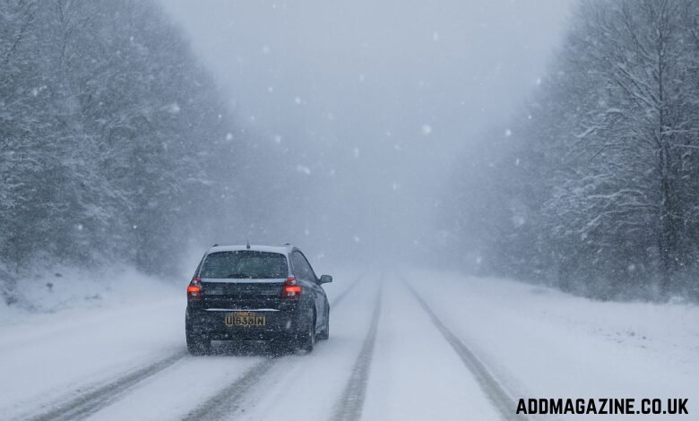
As December approaches, the UK is preparing for what is expected to be a significant weather event that could see the country grappling with a 411-mile snowstorm in the lead-up to Christmas. Weather experts have sounded the alarm as temperatures plummet and snow flurries are forecasted to hit several regions, with some areas bracing for heavy rain and possible flooding. With the festive season on the horizon, the nation is bracing for what could be a challenging winter storm.
Weather Maps Show High Alert for Snowstorm
UK weather maps have turned orange as a warning for the impending extreme conditions. The UK is on high alert for plunging temperatures, which could make the approach of Christmas particularly chilly. Projections from weather experts, including WX Charts, predict that December 7 will be the peak date for snow, with significant flurries expected to blanket parts of the country.
Regions such as Newcastle, Cumbria, and Northumberland are set to experience the brunt of the snowstorm in England, while Greater Manchester may also face significant snowfall. On the other hand, Cornwall and the southwest are expected to receive heavy rain, contributing to potentially dangerous conditions across various parts of the country.
While many regions are bracing for winter conditions, there are some areas of the UK that will be spared from the snowstorm’s impact. The Midlands and Northern Ireland are forecasted to stay dry, offering some respite from the severe weather.
Heavy Rain and Snow Expected
The weather pattern that is forming in December is expected to bring a mix of heavy rain and snow to the UK. The Met Office reports that Plymouth and Southampton could receive up to 75-80mm of rain, while cities like London, Birmingham, and Cardiff may see between 35-40mm of rain. These conditions could lead to localized flooding, especially in areas that are already prone to waterlogging from previous storms.
As temperatures drop in advance of the snowstorm, Scotland is likely to experience some of the coldest conditions, with temperatures hovering around 0-1°C. In England and Wales, temperatures may range from 4-5°C, though conditions will remain frigid, particularly during the night. The early December forecast suggests that areas not impacted by snow could enjoy dry, clear, and sunny spells, offering brief moments of relief from the harsh winter conditions.
Storm Bert’s Aftermath
This impending snowstorm follows closely on the heels of Storm Bert, which recently battered the UK, causing widespread flooding and forcing residents in affected areas to evacuate their homes. Storm Bert’s impact was felt across many regions, leaving behind significant water damage and prompting flood warnings in parts of England. The combination of this storm and the upcoming weather event has raised concerns about the UK’s infrastructure and how prepared the country is for these increasingly frequent extreme weather events.
The Met Office’s early forecast for December suggests that the UK could face a mixed bag of weather, with some areas experiencing milder conditions due to high pressure systems in the southeast, while others in the north and west will experience wetter and windier weather. The west will see rain pushing eastwards, which will then bring a short spell of wet weather to parts of the east, including the southeast and the Midlands.
Temperature Trends and Frost
Temperatures across the UK will fluctuate over the course of the coming weeks. The Met Office suggests that high pressure over the continent may extend its influence into the UK, bringing generally dry conditions. However, temperatures are expected to hover near average for much of the country, which means that overnight frost is likely to form in some areas, especially in rural and elevated regions. Daytime temperatures will remain cold, particularly where fog and low cloud persist.
By early December, low pressure systems could cross the UK, leading to short spells of rain and wind. The unsettled nature of the forecast suggests that the UK is not out of the woods yet, and it will likely be a while before the weather stabilizes. The prolonged period of cold and wet weather will create conditions conducive to the formation of frost, which could lead to hazardous driving conditions, particularly during the early morning hours.
Regional Breakdown of the Snowstorm Impact
- Northern Regions: The northern parts of the UK, particularly in Newcastle, Cumbria, and Northumberland, are expected to bear the brunt of the snowstorm. These regions are predicted to experience the heaviest snowfalls, with accumulations likely to disrupt travel and daily activities. The snow could affect roads, transport systems, and outdoor events as the festive season kicks off.
- Southern and Southwestern Areas: The southwest, including Cornwall, is expected to face a combination of heavy rain and wind, with some localized flooding possible. Areas like Plymouth and Southampton could see significant rainfall, leading to potential disruption in these parts of the country. In contrast to the north, the south will face milder temperatures but may still experience cold, wet weather.
- Central and Midlands Areas: The Midlands is expected to remain mostly dry, with clearer skies and colder temperatures, although fog and frost may be common in the early mornings. Northern Ireland is also expected to stay relatively dry, with little to no snow expected. However, colder conditions and overnight frost could still present challenges.
- Scotland: Scotland will experience some of the coldest temperatures, with forecasts predicting highs around 1°C. This makes Scotland particularly vulnerable to the formation of ice, which could impact transport and daily activities. Snow is also expected to accumulate in higher elevations, adding to the winter hazards.
Looking Ahead: What to Expect
As the snowstorm approaches, it’s important for residents across the UK to stay informed about the latest weather updates and to prepare for the potential impact. The government and local authorities have issued alerts for certain regions, urging the public to take precautions, especially in areas at risk of flooding or heavy snowfall. Those planning travel should anticipate delays, as the conditions could affect airports, rail services, and road transport.
Winter safety tips, such as dressing warmly, checking heating systems, and ensuring vehicles are properly equipped for icy conditions, will be crucial as the UK navigates this period of extreme weather. Given the challenging conditions expected, authorities have emphasized the need for heightened vigilance, particularly in regions predicted to experience the most severe weather.
Conclusion
The UK is gearing up for a significant weather event as it braces for a 411-mile snowstorm ahead of Christmas. With snow, rain, and plunging temperatures set to impact various regions, it’s clear that this winter will bring significant challenges. From potential disruptions to daily life to the added strain on infrastructure, this storm will test the UK’s ability to respond to increasingly severe winter weather events. As the snowstorm approaches, residents must stay informed and prepared to ensure their safety during the festive season.